A Bespoke Approach to AI and IT Solutions
Tailor-Made Solutions For Every Challenge
From automating BIM creation to optimizing smart grids, we leverage the latest advancements in AI, deep learning, and geospatial technologies to create scalable, high-accuracy solutions
Send us a task

ALL Use Cases
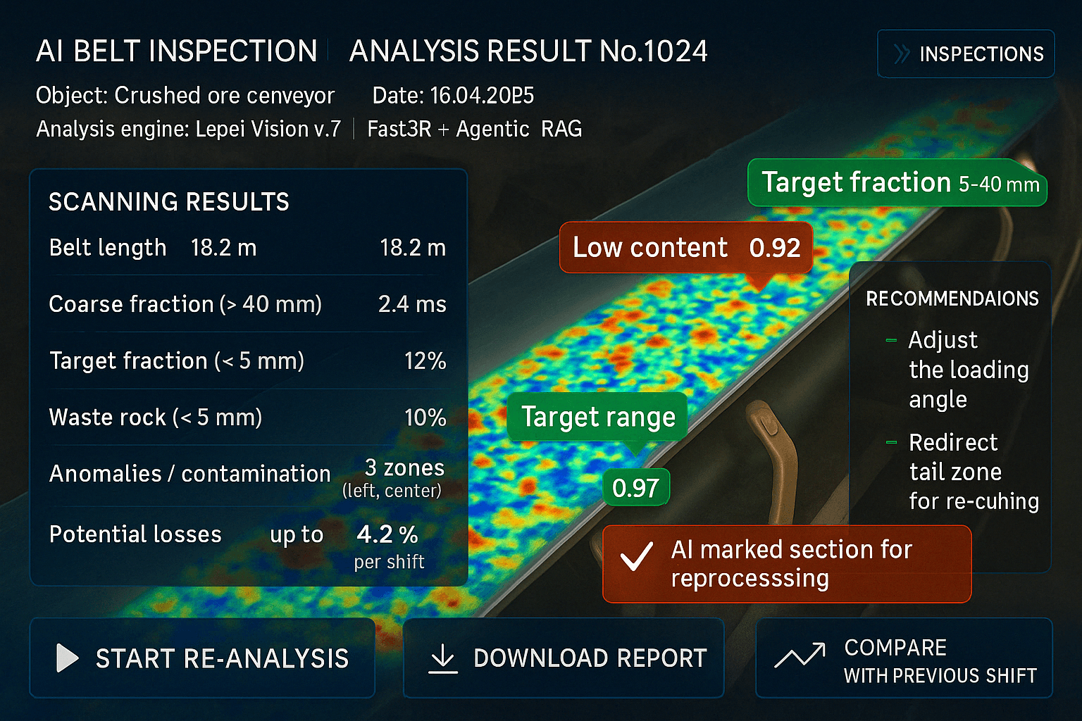
Problem:
Mining operations suffer from untracked ore loss and undetected process inefficiencies, costing hundreds of thousands annually.
Solution:
AI analyzes site video to detect ore loss, optimize loading, and flag production defects — with 48-hour reporting and heatmaps.
Results:
• Recovered up to 3% of ore, worth $200K/year
• Reduced process-related losses 10-20%
• Delivered ROI, no hardware changes needed
Find Out More

MEP AI Verification (Toronto, Canada)
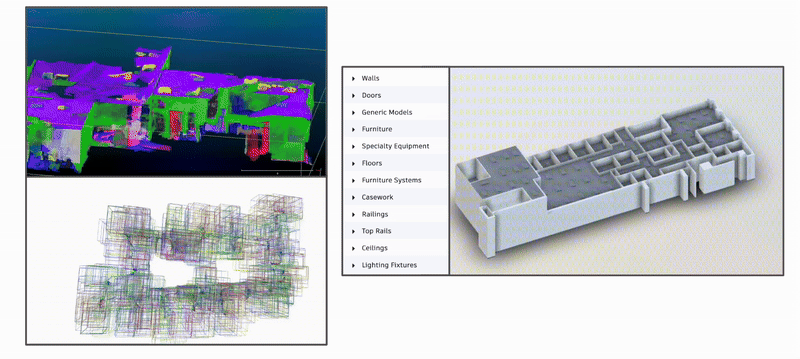
Problem: Errors in MEP (Mechanical, Electrical, and Plumbing) BIM models led to costly rework and project delays.
Solution: AI automated BIM verification, identifying inconsistencies before construction.
Results:
• Reduced manual verification time by 80%
• Cut rework costs by $200,000+
Find Out More
Problem: Renovation projects required fast and cost-effective BIM model creation.
Solution: AI converted video and point cloud data into BIM models, integrating seamlessly with Autodesk Revit.
Results:
• Eliminated manual modeling, reducing BIM creation time by 80%
• Enabled faster renovation planning and automated workflow integration
Find Out More

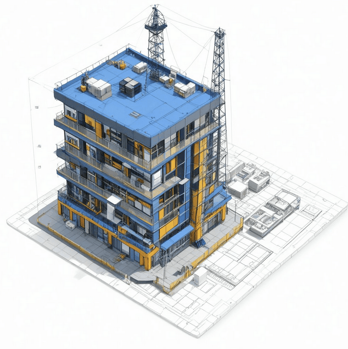
Problem: A complex urban district required a high-accuracy BIM model from diverse data sources.
Solution: AI integrated video, photos, LiDAR, and geospatial data to generate a BIM model.
Results:
• Delivered a complete BIM model in 36 hours
• Saved weeks of manual work and scanning expenses
Find Out More

AI-Driven Document QA
(Manchester, UK)
Problem: Construction companies faced up to 20% errors in project documentation, leading to costly mistakes and delays.
Solution: AI automated document quality checks, ensuring accuracy across naming conventions, metadata, and compliance.
Results:
• Reduced rework by 90%
• Cut manual verification time by 50%
Find Out More
AI-Powered Bridge Inspection (Global)
Problem: Manual bridge inspections were slow, expensive, and involved safety risks for personnel.
Solution: AI analyzed drone images and 3D scans to detect cracks, corrosion, and structural issues.
Results:
• Inspections completed 5x faster
• Increased defect detection accuracy to 80%+
Find Out More


Problem: Manually creating a BIM model for large-scale projects was slow and costly.
Solution: AI automated BIM generation from drone video and point cloud data, reducing manual workload.
Results:
• Created a LOD 300 BIM model for a 1,000 m² area in hours
• Improved scalability and project efficiency
Find Out More
Problem: Lengthy approval cycles and inefficient coordination between construction phases.
Solution: AI streamlined feasibility studies, procurement, and construction workflows.
Results:
• Reduced administrative overhead by 30%
• Improved decision-making speed by 25%
Find Out More

Structural Engineering & Construction Optimization (Sydney, Australia)
Problem: Manual processes slowed down structural and geotechnical engineering workflows.
Solution: AI automated defect detection, data exchange between platforms, and model optimization.
Results:
• Reduced engineering time by 30%
• Streamlined cross-platform data exchange and analysis
Find Out More
QTO Automation for Cost Estimating (Global)
Problem: Manual quantity takeoff (QTO) was time-consuming and prone to estimation errors.
Solution: AI automated QTO, ensuring faster and more accurate cost calculations.
Results:
• Reduced workload by 50%
• Decreased cost estimation errors by 80%
Find Out More


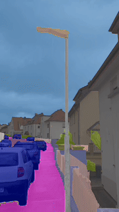
Problem: High energy costs and inefficient urban lighting management.
Solution: AI optimized smart grid lighting to reduce energy waste and enhance safety.
Results:
• Reduced energy consumption by 40%
• Improved public safety with adaptive lighting control
Find Out More

Problem: The municipality needed a comprehensive 3D inventory of its infrastructure for planning and maintenance.
Solution: AI integrated LiDAR, OpenStreetMap data, and aerial imagery to create a Digital Twin.
Results:
• Generated a full 3D city model in 12 days
• Provided real-time data updates for city planning
Find Out More
For more information on the technologies used, please follow the link
Types Of Data:

Satellite imagery
provides wide coverage and is readily available

Mapping layers from OpenStreetMap
are freely available and offer geospatial data such as roads and buildings
Drone video
provides fast coverage with a high resolution of up to 0.2 m

Mobile mapping technology
captures 3D data at a resolution of 0.03 m

LiDAR scanners
provide precise distance measurements and 3D data at a resolution of 0.01 m

360-degree video
provides fast and wide coverage at a resolution of 0.3 m
4K video
captures high-resolution visual data quickly at a resolution of 0.2 m

iPhone LiDAR
is a fast and convenient way to capture precise distance measurements and 3D data indoors
How it works
What Awaits You with Lepei?

Assessing your
existing workflow
Identifying bottlenecks where AI can reduce time & costs

Provide a report on potential savings and next steps
Get In Touch